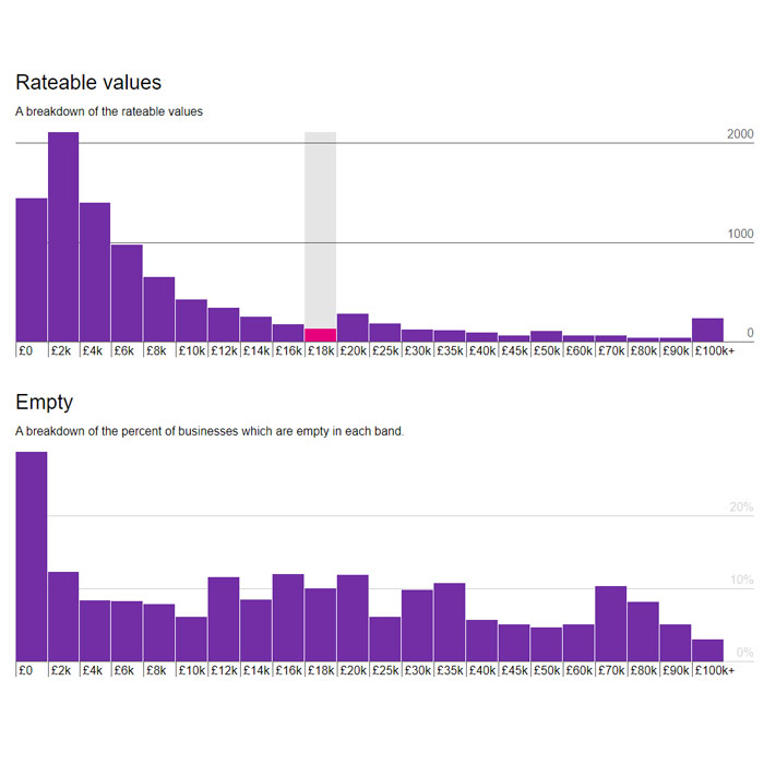
Logo
News
COVID-19
COVID impact assessment Datasets and visualisations Support for businesses
Data
Datasets Other open data sites Publishers Topics
Dashboards Projects Digital Calderdale
Get involved
Get Involved About Data Works Open Innovations Viewing different file formats The CKAN API
Login  Search
  •   Home
  • Projects

Projects

Projects, events and interactive visualisations

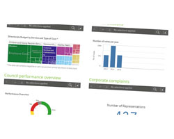
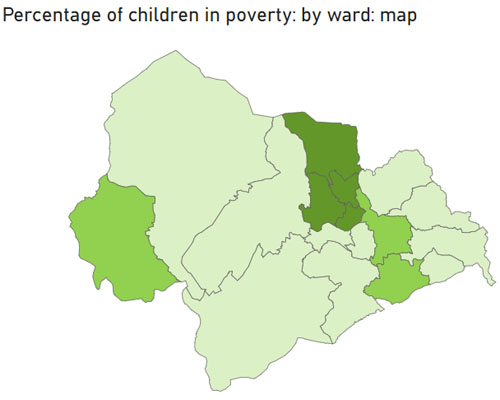
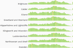
Find out more about some of our data, use the interactive visualisations and get involved in planned events and innovations using open data.

Ward profiles

Ward map of Calderdale

Dashboards

Snapshot image of Dashboards menu page

Census 2021

Census 2021 logo

Open Innovations

Open Innovations logo

Poverty dashboards

Image of a map from the Poverty dashboard

Climate emergency

Photo of wind farm

Calderdale population statistics

Sparkline graphs of population for wards

We are Calderdale

Vision 2024 logo

Indices of Deprivation

Indices of Deprivation map image

Open data saves lives

Open data saves lives logo

The Data City

The Data City

COVID impact assessment

Graphic image of a virus

Schools

Photo of school in Calderdale

Ward explorer

Snapshot image of Ward explorer screen

Air quality

Snapshot of Air quality dashboard

Working with universities

Calderdale Council and Huddersfield University logos

Local elections

Snapshot image of the Elections dashboard

Data mapper

Snapshot of the ODI Leeds Data mapper app

Business rates

Snapshot of Open Innovations Business Rates graphic

Active Calderdale

Active Calderdale logo

Energy performance certificates

Energy usage graphic

Council spending explorer

Image of several piles of pound coins

Digital strategy

Digital strategy logo

LCR Infrastructure map

Snapshot of the Leeds City Region map

West Yorkshire GeoJSON

Graphic design using binary codes

Flooding

Photo of flooding in the Calder valley

Brownfield sites

Photo of a brownfield site

IMD 2015

Snapshot frem an IMD 2015 factsheet

Ofsted reporting template

Local Government Association logo

Allotments

Snapshot of allotments mapped in Data mapper app

Open Transport North

Photo of a railway station

Ofcom Innovation

Ofcom innovation logo

#AirHack

#AirHack logo

     
Working With
DataPress Logo
  • Copyright © 2023
  • Visit calderdale.gov.uk